
Imagine you’re craving ice cream on a hot day. You pull up your phone’s map app. It drops a pin right on the parlor two blocks away. No wrong turns. That’s coordinates at work. They act as number pairs or sets that nail down exact spots in space. Think of them as addresses for points on graphs, maps, or even planets.
You meet them daily in navigation apps, video games, and weather charts. Coordinates power GPS to guide your drives. They help scientists track stars. Game developers place characters precisely. This post breaks it down simply. You’ll learn the basics, the Cartesian system, polar options, real-world apps, and fresh facts through 2026. By the end, you’ll see coordinates everywhere and grasp how they click.
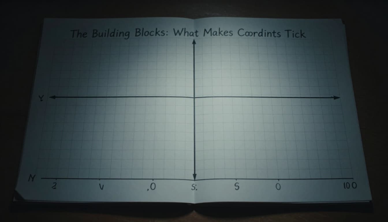
The Building Blocks: What Makes Coordinates Tick
Coordinates describe a spot’s position from a fixed start point, the origin. They skip vague words like “over there.” Instead, numbers tell you exactly where to go. Picture graph paper. Each square intersection holds a potential point.
Most start in 2D, like a flat map. Two numbers suffice: one for side-to-side, one for up-and-down. 3D adds height, but basics first. Everyone uses a grid. Streets form one in cities. Treasure maps use letter-number combos, like B3.
Axes form the backbone. The x-axis runs horizontal. The y-axis stands vertical. They cross at the origin. Positive x goes right. Negative x heads left. Y works up or down. Directions matter because they define position.
Analogy time: Think of a room. Origin sits at one corner. Walk right five steps for x=5. Climb a ladder three rungs for y=3. You’re at (5,3). Simple, right?
Starting from Scratch: The Origin and Axes Explained
The origin marks (0,0). It’s home base. Everything measures from there. No movement means zero.
X-axis stretches left and right. Positive values pull right, like east on a map. Negative swing left, west. Arrows show direction. Y-axis rises up or falls down. Positive climbs north. Negative drops south.
City blocks mimic this. Main Street is x. First Avenue is y. Corner of Main and First? That’s (0,0). Block east is (1,0). North one block becomes (1,1). Kids learn it fast with such grids. So, axes give structure. They turn chaos into order.
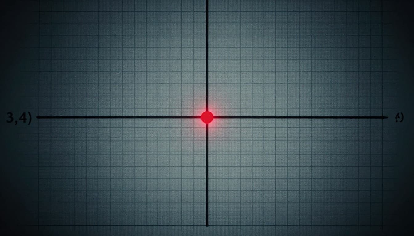
Cartesian Coordinates: Your Go-To Tool for Straight-Line Plotting
René Descartes dreamed up (x,y) pairs in 1637. He merged algebra and geometry. Now, they’re standard for graphs. Britannica details the history. Plot by moving x first, then y.
Start at origin. Positive x shifts right. Negative x goes left. Then y: up for positive, down for negative. (3,4) lands three right, four up. First quadrant hosts it, where both stay positive.
Quadrants divide the plane. All points fit one. Examples help. (-2,5) sits second quadrant: left two, up five. City planners use this for blocks. East three, north four? Park at (3,4).
Students graph grades too. X for test number, y for score. Trends pop clear. Distance between points? Square differences, add, square root. Tease for later.
mathsisfun.com offers clear visuals.
Plot Your Point: A Foolproof Step-by-Step Guide
Follow these steps every time.
- Begin at (0,0).
- Count x units. Right for plus, left for minus.
- Move y units from there. Up positive, down negative.
Take (3,-2). Go right three. Drop two. Done. Practice on paper. Mark ten points. Check against apps. Speed builds fast.
Quadrants Unlocked: Where Every Point Lives
Four quadrants rule. First: both positive, top-right. Happy, high-energy spot on an emotions graph.
Second: x negative, y positive. Top-left. Third: both negative, bottom-left. Fourth: x positive, y negative. Bottom-right.
Plot moods. Joy at (4,3) first. Worry (-2,2) second. Each tells a story. Quadrants organize chaos.
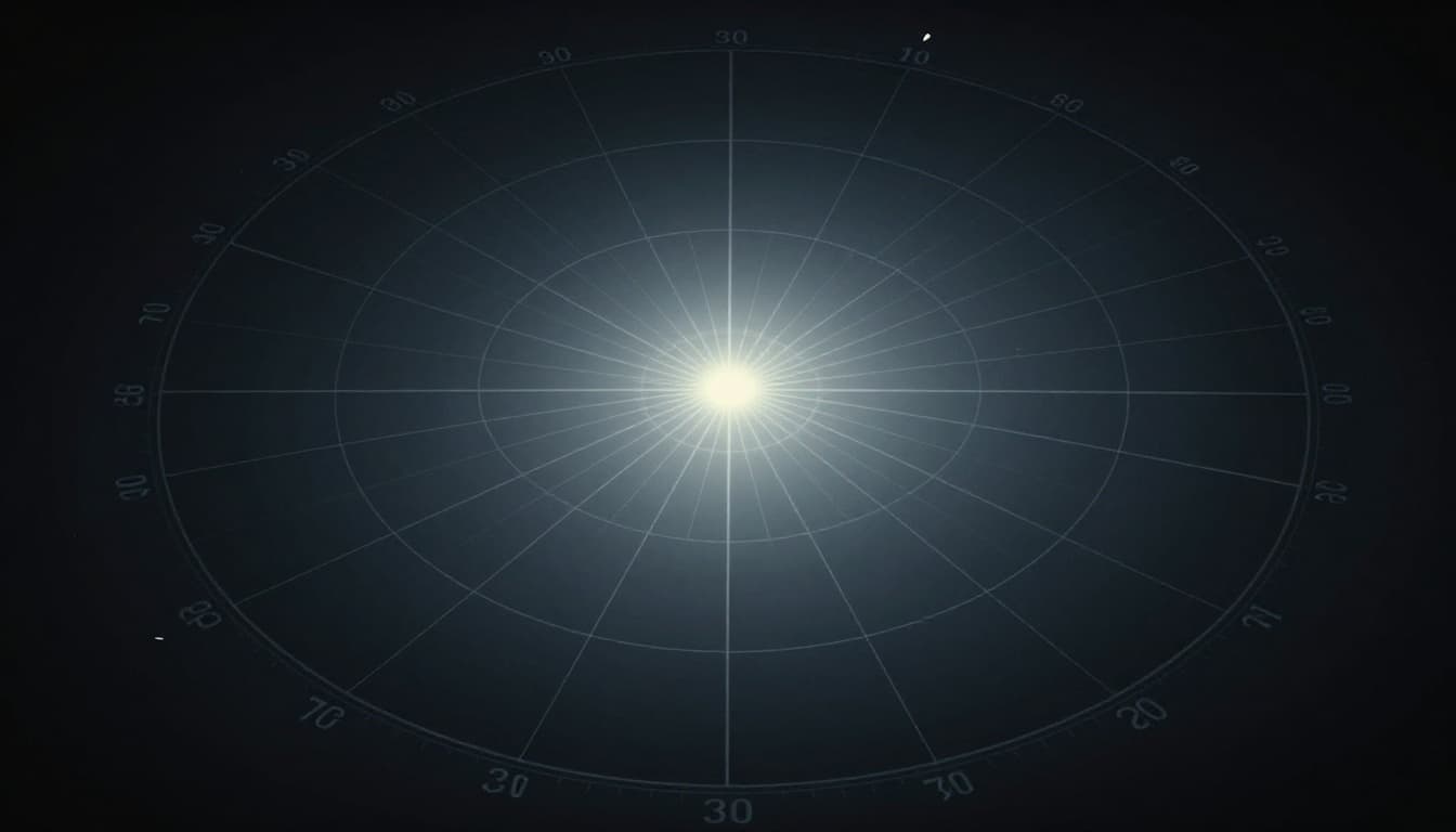
Polar Coordinates: When Angles and Distance Shine
Polar skips straight lines. It uses radius r from origin and angle θ from positive x-axis. Great for circles, radars. (5, 30°) means five units out, 30 degrees counterclockwise.
Radar screens love it. Blips show distance and direction. Sound waves spread circular, so polar fits. Ships navigate with it too.
Convert easy. x = r cos θ. y = r sin θ. (5, 90°) hits (0,5): straight up. Reverse uses Pythagoras and arctan.
mathsisfun.com explains conversions.
From Angle to Point: Easy Conversions
Common angles simplify. 0°: along x-axis. 90°: y-axis. 180°: negative x. 270°: negative y.
| Angle (°) | (r, θ) Example | Cartesian Equivalent |
|---|---|---|
| 0 | (4, 0) | (4, 0) |
| 90 | (4, 90) | (0, 4) |
| 180 | (4, 180) | (-4, 0) |
| 270 | (4, 270) | (0, -4) |
This table speeds practice. No calculator needed first. Polar shines for rotation symmetry.
Coordinates in the Real World: From GPS to Games
GPS uses latitude and longitude. Like y/x on Earth. Add z for altitude. Maps mark B3 grids. Data trends plot on graphs. Games position heroes in 3D.
Drones blend systems. 2026 AI corrects GPS drift for sub-inch maps. Self-driving cars map roads with LiDAR points. TechTarget covers GPS basics.
Video games track every jump. Swarms coordinate via angles.
3D Coordinates: Adding Depth to Your World
Add z-axis for depth. Up positive, down negative. (x,y,z) like (2,3,1). Drones hover there.
Games make characters leap: start (0,0,0), end (5,0,10). Wireframes guide paths.

Fun Facts and 2026 Twists You Did Not Know
Descartes invented Cartesian watching a fly on his ceiling. Sick in bed, he numbered its path.
Polar suits spirals. 2026 drones use AI hybrids for inspections. Quantum sims position qubits, but basics hold.
No big shifts. Systems evolve quietly.
Master Coordinates Today
Coordinates boil down to Cartesian straight shots and polar curves. They pinpoint GPS routes, game worlds, drone flights. From graphs to galaxies, they organize space.
Grab paper. Plot (3,4). Try polar (5,45°). Apps like Desmos help. Share your wildest GPS tale in comments. Subscribe for more math breakdowns. Coordinates fuel tomorrow’s tech. You handle them now.